


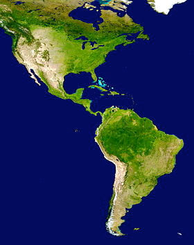
Spanish Explorers In North and South America


During the 1400s and 1500s, the Americas were being explored by many explorers from other countries. We are going to focus on Spain. Spain wanted to find more gold and other riches to bring to their country. The king and queen sent many CONQUISTADORS (Spanish explorers) to the Americas to find wealth. Remember that North and South America were not called these names yet.The Spanish referred to them as the "New Worlds."
In this lesson, we will discuss Hernando de Soto, a famous conquistador from Spain who was influential in Alabama and other areas. Hernando de Soto changed the history of the Americas because his presence had a long-lasting impact on our world.
Hernando de Soto In North America
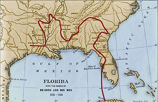
In April of 1538, Hernando de Soto landed in North America after visiting Cuba. He landed in Tampa Bay, Florida in 1539. He traveled through Florida, Georgia, and Alabama. While in Alabama, de Soto and his 700 men had a battle with the Native Americans around present-day Mobile. This resulted in a major loss of Native American and Spanish lives.
De Soto is often credited with discovering and/or crossing the Mississippi River. This discovery made a large advancement in exploration of the mid-west of North America.
While Conquistadors contributed greatly to the exploration of the Americas, they also caused great devastation. They brought smallpox and other diseases to the Native Americans that inhabited these landmasses. Native Americans began to die of these diseases that the Spanish brought.
Want to learn more? Click below.
https://www.history.com/topics
/exploration/hernando-de-soto
https://fcit.usf.edu/florida/lessons/de_soto/de_soto1.htm

Learn with AHFA
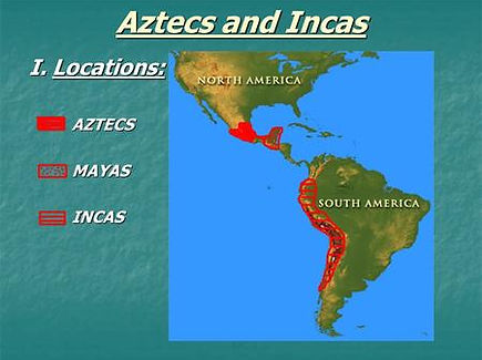
Spanish Settlement in South America
Spanish settlement in South America impacted the Inca and Aztec empires in many ways. These two Native American tribes also suffered from diseases from the conquistadors. Eventually, the tribes were captured and defeated by the conquistadors. The riches that the explorers gained from these empires were not nearly as much as they expected. The Spanish wanted to conquer these lands in hopes of finding gold and silver.
Want to know more? Follow these links.
http://www.digitalhistory.uh.edu/disp_textbook.cfm?smtID=2&psid=3573
https://www.history.com/this-day-in-history/aztec-capital-falls-to-cortes
Assignment!
Research Hernando de Soto and create a map of his path in Florida, Georgia, Tennessee, Alabama, and Mississippi. You can use the maps that I have shown. Use your imagination. Remember that he stopped near Mobile and had a battle with the Native Americans. Locate Mobile on your map and put a black 'X' over the spot. Locate the Mississippi River in Mississippi and draw it with a blue marker or crayon (just in Mississippi). A map key must be in the drawing with at least two elements. Be sure to use the internet to find a map. Be creative! You can include extra landmarks and colors, but be sure to include Mobile and the Mississippi River. Be sure to label each state CORRECTLY. Lines of states do not have to be completely accurate, but try your best using the maps and the internet.
RUBRIC: http://rubistar.4teachers.org/index.php?screen=ShowRubric&rubric_id=2774255&
Lesson/Training Plan: Spanish Colonization of Alabama
Teacher: Adelaide Hittson
-
Grade Level: Third grade
-
Subject/Topic: Social Studies- Colonization
-
Duration: 60-120 minutes
-
Materials: Computer and Smart Board for virtual tour, tablets or personal computers, phones, map to show students where de Soto traveled and how it looked in the 1400-1500s, construction paper, colored pencils, markers, crayons, scissors, tape, and glue for the activity.
-
Standards:
6 ) Identify conflicts within and between geographic areas involving use of land, economic competition for scarce resources, opposing political views, boundary disputes, and cultural differences.
8 ) Identify geographic links of land regions, river systems, and interstate highways between Alabama and other states. (Alabama)
11 ) Interpret various primary sources for reconstructing the past, including documents, letters, diaries, maps, and photographs.
-
Students should have prior knowledge of Native Americans. Students should know where Alabama is located on a map. Students should understand that Native Americans were the first inhabitants of this land. Students should have knowledge that it was not always called Alabama and that the explorers were here before it looked like it does now. The teacher should have knowledge of former Native Americans in Alabama and Hernando de Soto’s journey. De Soto traveled from Florida, Georgia, and Tennessee to Alabama in his quest for gold. He destroyed many villages along the way. The following article gives knowledge to the paths he took: https://www.history.com/topics/exploration/hernando-de-soto
-
Introduction: The teacher should ask the students what they know about how important the history of Alabama is. Then, the teacher should ask students about Native Americans and how they are important to us. Next, the teacher should tell the students that history has been made right where the students are sitting. This creates a hook and shows them how history happens everywhere.
-
Activities/Procedures: The teacher should show the students how to navigate the virtual tour. Next, the teacher should show the map of how Alabama looked when this information took place. The teacher should explain every picture in the slide so the student has a clear understanding of the whole concept. The teacher should ask the students about diseases and smallpox and Native American life before the conquistadors came to Alabama.
-
Main Activities/Assignments: For the main activity, the students should draw a map with De Soto’s path from Florida to Georgia to Tennessee to Alabama to Mississippi. This will show where De Soto traveled. They are essentially recreating the map that the teacher has shown them in class multiple times. They can add a treasure chest, color battles along the way, and include water and cities. A map key must be in the drawing with at least two elements. Students must be able to understand the general area. No points will be deducted for state shapes. They can use the maps and other online resources to draw this.
-
Resources: ALEX- https://alex.state.al. us/plans2.php?std_id=56321
-
WIX
-
History.com: https://www.history.com/topics/exploration/hernando-de-soto
-
Rubistar
Want to learn more about the Spanish Conquistadors?..
https://www.ducksters.com/biography/explorers/spanish_conquistadores.php
https://www.britannica.com/topic/conquistador-Spanish-history
http://www.bbc.co.uk/history/british/tudors/conquistadors_01.shtml